
This article defines the parts of the project details page, where you will configure your Route project details.
Project Details
Select the New Project icon to begin the process of creating a project.
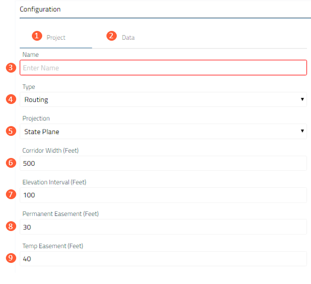
| 1. Project Tab | Where a user can set up the parameters to start a New Project. |
| 2. Data Tab | Where a user can upload any project-specific proprietary data. Data must be stored in a zipped Shapefile. |
| 3. Name |
The Name you assigned to the project. Once a project is created, it can be accessed by anyone within the same Account. Note: Projects in Route will be archived if no change has occurred to Project Settings, Objectives, PLAE, Exclusion Areas or Routes within one calendar year. To learn more visit the help center article, Archiving and Restoring a Project. |
| 4. Type |
Routing - application is being utilized to generate both Routes and crossing and impact Reports. Reporting - application will only generate crossing and impact Reports for uploaded routes. Electric Transmission Routing - application is being utilized to generate both Routes, crossing and impact Reports, and planning Cost Estimates. |
| 5. Projection |
Projection is used for calculating the length of the route(s), route stationing, mile posts, and other aspects of the generated reports, including acreage. All calculations are in feet. Note: The chosen Projection configuration will not have a significant impact on the outcome of the routing or reporting process. It is mostly a selection based on the preference of the Account. |
| 6. Corridor Width |
Defines the width of the project corridor for reporting purposes. Note: Corridor Width has a size limit of 1 mile (5280 feet). The larger the corridor, the more data will be included in the associated reports. A larger corridor will impact processing time. |
| 7. Elevation Interval |
Sets the interval in which elevation values are defined in the reports. Note: Elevation data is derived from 10-meter DEMs. An elevation interval that is set too low may generate repeating values in the reports. An interval of at least 30 feet is recommended. |
| 8. Permanent Easement | This configuration is not currently utilized in the application. |
| 9. Temporary Easement | This configuration is not currently utilized in the application. |
Next Step
Configure Route Objectives