
Co-Location is when a system generated route favors an existing corridor for Pipelines, Powerlines or Transportation infrastructure.
- Enabling the Co-location function makes features meeting user-defined criteria more attractive to the routing process.
- The criteria consist of a linear corridor (Existing Pipelines, Powerlines, or Transportation), as well as a Land Ownership type. You may decide to use all or some of these settings depending on the needs of the project.
Getting Started
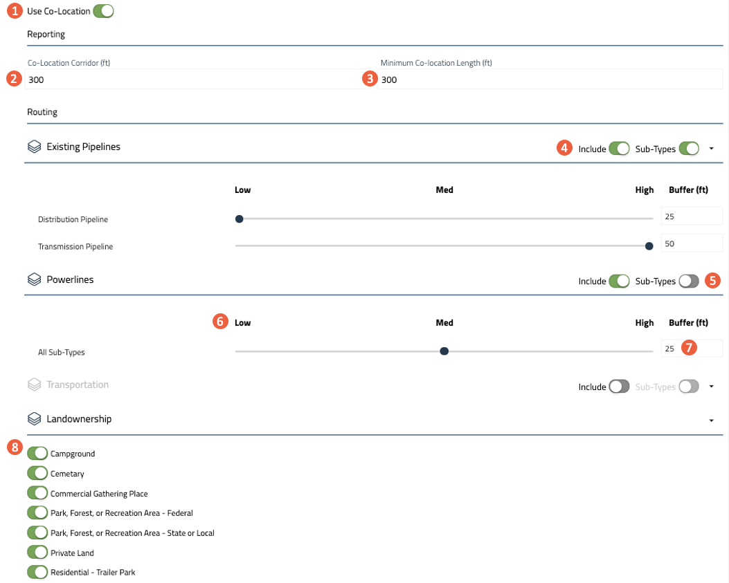
| 1. Use Co-location | |
| Co-location Reporting Settings | |
| 2. Co-location Corridor |
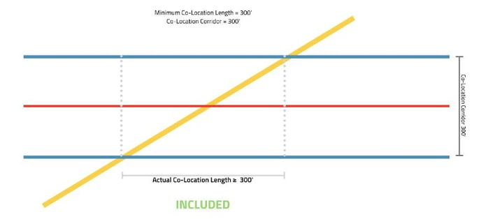
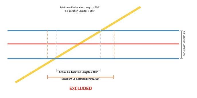
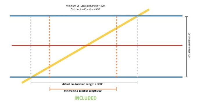
* FOR REPORTING PURPOSES ONLY Used to determine the corridor width for reporting on features that are Co-located with the route, within the defined corridor. Existing Pipelines, Powerlines, Roads, and Railroads that fall within the Co-location corridor will appear in the Detailed Reports and Summary Report. (Minimum Setting = 25ft, Maximum Setting = 750ft) |
| 3. Minimum Co-location Length |
* FOR REPORTING PURPOSES ONLY The distance the route is Co-located with a given feature. All segments of the route which are Co-located for a distance greater than or equal to the set value within the corridor will be reported as Co-located. (Minimum Setting = 1ft, Maximum Setting = 5280ft) |
|
Co-location Reporting Setting Summary
How the length of a co-location feature is determined |
|
 |
|
|
|
 |
|
|
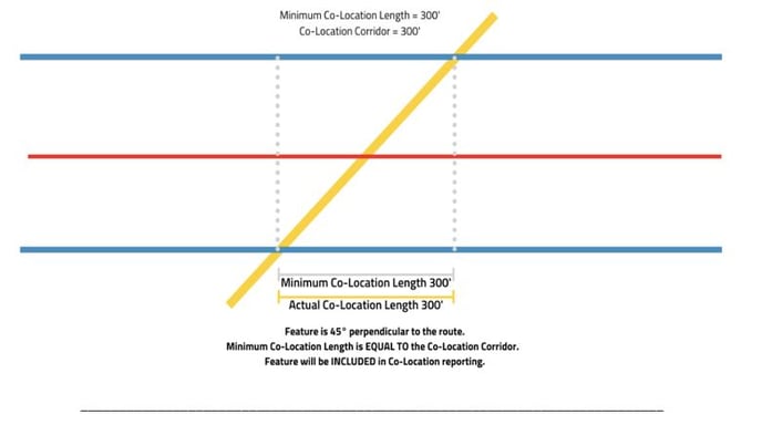
How the Co-location Corridor setting impacts what's included in a Route report Example 1
|
|
|
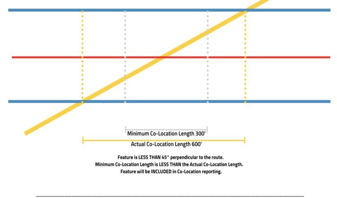
Example 2
|
|
|
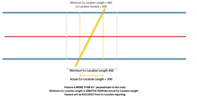
Example 3
|
|
| Co-location Routing Settings | |
| 4. Include Source | Toggle to include or exclude in the Co-location process. |
| 5. Sub-Types | Toggle on/off Sub-Types to apply the same weight across all sub-types within a source. |
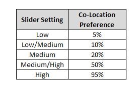
| 6. Co-location Preferences |
For included Sources and Sub-Types, use the slider to set the Co-location Preference, encouraging the application the place importance on routing within existing infrastructure corridors: |
| 7. Buffer (feet) | Sets the corridor width where the routing tool can Co-locate with a feature. |
| 8. Land Ownership Type | Toggle on/off the listed Land Ownership type(s) to allow Co-location within these areas. |
Notes:
The above example will set a High preference for a System Generated route to be Co-located with Existing Pipelines and a Medium/High preference to be Co-located with Powerlines. Co-location will be applied to existing corridors on Private Land. Corridors on Federal and State Land will not be included in the preferences.