View, Interrogate and Export Individual Constraints
Currently, Pivvot users are unable to visualize constrained areas within Siting. This has presented challenges as users attempt to interrogate the impacts of constraint features on the usable area. This is no longer the case.
In the Project Sites tab, all constraint columns now have the flash and map capability. This will allow you to display the specific impacts of an individual constraint. We’ve taken this a step further by updating the KMZ and data package exports. The KMZ now contains the individual constraint features along with their associated acreage and percent coverage. This information is also available in the Constraint feature class in the data package file geodatabase.
Click to Search on Pivvot Layers
The click to search capability in Siting has been isolated to Pivvot layers that are used to set a Center Location for prospecting. We have expanded this capability where you can now click on the map and view details for the Pivvot layers listed below.
· County Boundary
· Depth to Bedrock
· Electric Retail Service Territories
· Floodplain
· Geologic Unit
· Hydric Soils
· Infrastructure and Structure
· Interconnect Queue
· Landownership Conflict
· NHD Flow/Waterbody
· NWI
· Pipelines
· Powerlines
· Property Parcel
To customize the search further, the user now has options to narrow down the search to a Center Locations search or a Pivvot Search.
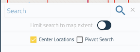
By selecting “Center Locations,” all results in the search panel will filtered to layers that can be used as a center locations. By selecting the “Pivvot Search,” search results will display information for the layers listed above. This new feature will allow you to customize search so you can locate information quicker.
If you have any further questions about these new updates, please reach out to support@pivvot.com.