Choose a Center Location
Before you can locate prospective sites you'll need to identify a location from which to begin your search. You can choose from from Pivvot features or manually define your Center Location.
Below is a list of possible Center Locations:
- Pivvot Layers
- County
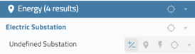
- Substation(s)
- Powerlines
- User Defined Location
- Drop a point on the map
- Draw a line on the map
- Draw a polygon on the map
- Upload a KML/KMZ file (point, line, polygon)
Pivvot Layers
There are two ways to find the county, substation(s), or powerline you'd like to use as a Center Location.
- Map Search
- Click to Search
Map Search
To locate a county or substation(s) Map search:
- Click the Map Search icon next to the Siting Criteria search panel
 . Slide the Limit to center location results slider to the right.
 - Search for a county name. The county and all of the substations in the county will be displayed.

- Choose the map point icon to add the county or substation as the center location.

The green section will display Google Places to what you see in Google Maps. This means you can search for a common place or street address. You can also search for a lat/long coordinate.
Click to Search
1. Click on an energy infrastructure feature on the map such as an existing substation or powerline
2. Select the Center Location icon next to the substation name in the search panel

3. To add a second substation to your search, click on a substation on the map. In the search results panel, click the plus/minus icon next to the substation to add it to your center locations.
The ability to prospect around multiple features is limited to substations found in the Pivvot Substation layer.
User Defined Location
1. Choose a point, line, polygon as your center location. Or, upload a KML/KMZ file.
![]()
Configure Siting Criteria
Once you set your center location, you need to configure your siting criteria in the siting search panel. To configure your siting criteria consider the distance filters for the variables you are interested in when looking for a site.
Project Usable Area
Once you set your center location and the distance from which you would like to search, click the Generate AOI icon to display the boundary of your search area of interest on the map

Once saved, you can also generate usable area for the AOI by clicking the Calculate Usable Area icon: 
Parcel Type: Smart Parcels and Tax Map Parcels
When choosing parcel type, you have the choice of Smart Parcel or Tax Map.
- Smart Parcels are a curated dataset from Pivvot that is an aggregated tax map based on land owner opportunity.
- Tax map parcels are the parcels that are accessible through the county.
Owner Details
To search for parcels owned by a specific individual or organization within your project Area of Interest (AOI), enter the full name or a portion of the name of the parcel owner.
Min and Max Parcel Size
If you are seeking a parcel of a specific size, you can refine your search by selecting the minimum and/or maximum parcel size options. Please note that the maximum allowable size is capped at 100,000 acres. If you wish to remove this upper limit, uncheck the maximum size box to broaden your search parameters.
Distance Filters
You can configure and select up to three distance filters per search. Click the "new distance filter" button to open the distance filter menu.

Choose a distance filter from the dropdown list.

Select the sub types you would like to use in your search. For example, to configure the KV capacity of the substations and powerlines you would like to use as siting criteria, check the box next to substations, powerlines, or both. The cog wheel icon will turn red to indicate there is further configuration needed. Click on the cog wheel icon to open the subtype configuration screen. Move the available sub types to the selected sub types column to prospect for sites near this type of substation or powerline.
 .
.

Additional filter functionality for Substations, Powerlines, and Existing Pipelines.
Substations: Users can now conduct distance filters based on either Subtype (kV) or Status (abandoned, operational, under development).
Powerlines: Users can now conduct distance filters based on either Subtype (kV) or Status (abandoned, cancelled project, idle, operational, under development).
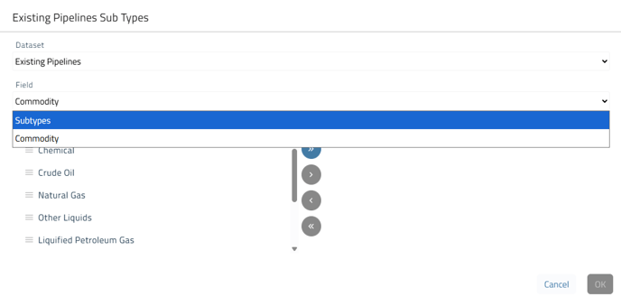
Existing Pipelines: Users can now conduct distance filters based on either Subtype (distribution pipeline, gathering pipeline, transmission pipeline, transmission pipeline storage header) or Commodity (chemical, crude oil, natural gas, other liquids, liquified petroleum gas, natural gas liquids, miscellaneous, refined petroleum products, water).
Existing Pipeline example:
After configuring the subtypes for your chosen filter and clicking OK, the filter will be added to your list. You have the option to add as many as five filters and select up to three for your search. Additionally, you can customize the distance for each filter according to your specific requirements.

To remove a distance filter from the list, click on the trashcan icon. To reconfigure the subtypes, click on the gear icon.
Once all variables are chosen, select Find Parcels.
You can edit and run your search again once you get your results.
You can also run an Area of Interest (AOI) usable area search to search for usable area first and then select the parcels within that area. Using the AOI Search in Siting